
Houston seawall repair & shoreline planning
Houston-area projects need clear property and access records. Confirm the private work area, nearby public-land boundaries and habitat conditions before designing the shoreline.
Describe your project on this page ↓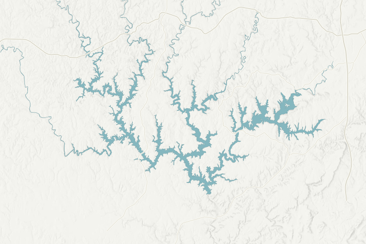
Map sources & limits
Lake shoreline and selected roads: U.S. Census Bureau, 2025 TIGER data. Terrain: USGS 3D Elevation Program. Community points: cited place records. Reviewed November 4, 2026. Simplified for orientation; not a property survey, current waterline or navigation chart.
Get to know your waterfront
Houston is an unincorporated Winston County community and a former county seat. The Forest Service’s Houston Recreation Area is on Smith Lake and provides a recognizable nearby lake reference. Private shoreline work remains a separate matter: recreation access does not establish a contractor route, a property boundary or permission to alter the bank.
Wikipedia · Houston Place · US Forest Service · Bankhead National Forest recreation guide · Winston County Circuit Clerk · Winston Contacts
Verify the land classification and access permission first
Ask Alabama Power to identify the shoreline classification and conditions for the actual lot. Its shoreline-plan materials distinguish multiple-use, recreation, forest and other lands. A private residence near public land should not be treated as permission to cross that land or work on its shoreline.
The Houston recreation facility has a launch and day-use amenities according to the Forest Service. Any proposed use for loading construction materials needs a separate conversation with the land manager. Have the contractor provide an alternative if that use is unavailable.
Once boundaries and access are clear, check whether sensitive-resource or turtle-habitat conditions affect the work. Natural stabilization, timing and close-out should be settled before final pricing. Use the county parcel record to keep the correct landowner and work location attached to every request.
Local details that change the questions
- Houston is an unincorporated Winston County community.
- It is a former county seat; current county offices are in Double Springs.
- Houston Recreation Area is a Forest Service facility on Smith Lake.
- The recreation guide identifies a boat launch, trails and picnic facilities there.
- Alabama Power’s shoreline-plan records distinguish recreation and forest land from other classifications.
Related planning: Winston County shoreline guide · riprap scope · condition assessment.
What could the work cost?
Price only a confirmed access route. Include any natural-stabilization planting, material handling and follow-up obligations so the estimate covers the approved system.
These are national price ranges from HomeGuide, not Smith Lake quotes. Wall height, access by land or water and the work included can change your total.
Compare quotes and plan a budget →Find the relevant permits and records
| Starting point | What to resolve | Prepare and look up |
|---|---|---|
Alabama Power · Smith Lake | Shoreline structure and bank work within project rights. | Permit tag, deed, parcel, existing and proposed sketch. Call 205-384-7385. |
Winston County | Confirm parcel jurisdiction, road access and applicable local reviews. | Use the actual property address and parcel number; a mailing city is not a jurisdiction decision. |
ADEM / USACE when applicable | Construction stormwater and federal in-water or fill authorization. | Complete disturbance area, method, footprint and disposal plan. |
A boundary and access confirmation file
Use this sequence to prepare the site-specific records and questions. It is a planning checklist, not an approval or a contractor availability claim.
Locate the private lot
Combine the deed, survey and county parcel record.
Ask about the shoreline class
Get the applicable conditions from Alabama Power.
Confirm the proposed approach
Name each landowner or public manager whose permission is needed.
Set the work conditions
Record habitat method, timing and close-out requirements in the contract.
Tell us about your Houston area shoreline
Use the lake-property location and describe the change you noticed. Add the existing tag or survey later if available.
Clear guidance for your lakefront project.
Houston project questions
Can a Houston lake project rely on the recreation-area launch?
Only after the relevant manager confirms that the proposed construction use is allowed. A public launch listing is useful for orientation, not proof of commercial staging rights.
What should I send before an assessment?
Start with the actual lake location and safe, dated photos. Existing approval tags, surveys and repair records help the professional understand the scope. Use the assessment checklist to organize them.
Keep planning
Nearby waterfront guides
Show sourcesHide sources
- Wikipedia · Houston PlaceSource reviewed 2026-11-04
- US Forest Service · Bankhead National Forest recreation guideSource reviewed 2026-11-04
- Winston County Circuit Clerk · Winston ContactsSource reviewed 2026-11-04
- Smith Lake residential shoreline guidelines · July 2025Source reviewed 2026-11-04
- ADEM · Adem StormwaterSource reviewed 2026-11-04
- USACE · Regulatory Request SystemSource reviewed 2026-11-04
- Alabama Power · Warrior River shoreline-plan updateSource reviewed 2026-11-04
- Smith Lake enhanced natural stabilization contractor guideSource reviewed 2026-11-04